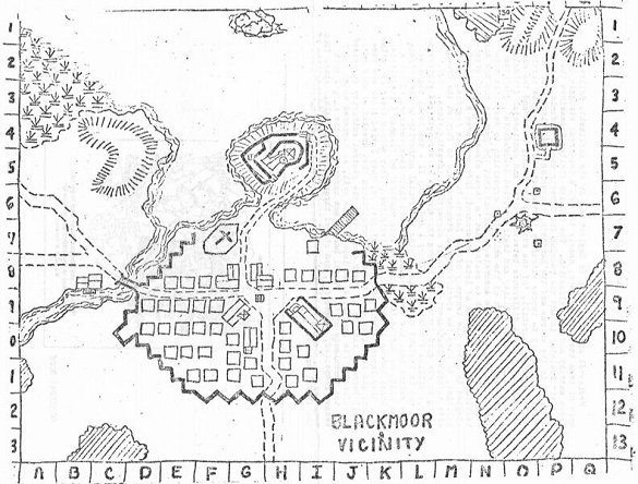
Above is the map Blackmoor Village accompanying Arneson's article in the Castle & Crusade societies' Domesday Book #13 circa Jul 1972. We have a couple versions of this map, but they are all much the same in principal detail. All of them show Svenson's Freehold toward the upper right corner of the map, and that detail let's us know that the map as it appears could not have been drawn much more than a few months before being printed in the Domesday book.
1971-1972 was Greg Svenson's senior year of High School. In the fall semester, he took advantage of an opportunity to take a class in architecture taught by his assistant football coach, Mr. Pike. Greg was inspired by what he learned in that class to draw the plans for Freehold.
In Arneson's Blackmoor Gazette & Rumormonger #2, from circa May of 1972, we can see that Freehold has already been built. The newsletter mentions "...some weeks ago when Swenson's Freehold was wiped out..." and further along it says "... until Swenson's Freehold is rebuilt and restocked..."
So it is likely the Domesday book village map dates to the winter of 1971-2 and certainly not before Greg's architecture class in the fall months of 1971.
Given that the first recorded games set in Blackmoor took place in March and April of 1971, one of which involved the infamous Troll Bridge of Blackmoor Village, we can safely presume there was some sort of an earlier version with no Freehold.
It's entirely possible this earlier map was nothing more than a sketch Arneson made on the butcher-block paper he spread on his gaming table, and maybe the only difference was the absence of Freehold. Whatever the case, the point to note here is that some other map of some kind existed before the one we now know of.
We do have another map of at least a part of the village of Blackmoor, as shown on the Level 4 tunnel map in the FFC.

The original from which the FFC level 4 maps were redrawn cannot be dated quite as closely. It does exist early in 1972, because portions of it were mapped by Dave Megarry while playing the character H. W. Dumbo and what we see printed in the FFC matches Megarry's hand-drawn map quite well. We also have a brief log Megarry kept for the Dumbo character that runs from January to September of "1052" which evidently corresponds to 1972.
Since the date ranges for the Domesday Book map and the Level 4 Tunnels map overlap, either of these maps could have come a few months before the other, but in any case they are different. The village map shows a somewhat different building arrangement. The buildings placed around the square - such as the Church and the Store are at angles to the rest of the town, whereas the tunnels map shows the buildings aligned at right angles, further apart on the East/West axis and somewhat closer together on the North/South Axis.
These differences make aligning the tunnel map to the village problematic. It is possible to get them close-ish, but it is clear they don't fit. An even bigger problem comes in when the tunnel map is then scaled to fit the Level 4 dungeon map. These two maps by themselves fit together pretty well and it is easy to see how they are intended to match. With all the levels thus properly aligned to each other and to the tunnel maps, it is possible to see where any given level falls in relation to the town (see the Gimp file in the previous post). The image below may be a little hard to see, but it shows Level 1 of Blackmoor dungeon superimposed over the town map aligned to the Level 4 tunnel map as closely as I can get it.

As can be seen above, Level 1 of the dungeon, which is in the hill of Blackmoor Castle around 75 feet above town level, extends well outside the hill, far into the air above Blackmoor Bay!
So the Referee is faced with 3 possible solutions.
1) pretend the dungeon is "bigger on the inside", Tardis like, but magically connects somehow with the surface just where it should.
2) shrink the dungeon maps to fit the surface topography and ignore where it falls on the surface map.
3) redraw the town map to fit the dungeon and tunnel maps as they actually are.
Solution 1 is a perfectly fine use of Handwavium - and the one just about everyone, including Arneson, has employed. It works, but it is hardly satisfactory for a long term campaign around Blackmoor where knowing exactly what is where is very useful.
Solution 2 results in all sorts of weirdness regarding where things align and is best forgotten.
Solution 3 required a bit of work, but in the end gives the best results. So here it is: A map of the village and castle of Blackmoor designed as an accurate fit to the dungeon and tunnel maps.
This map could use a bit more polish (once again, I'm no Rembrandt nor do I have endless amounts of time) but it will get the job done. So, if you are so inclined, you can use this map and be confident you know exactly where the entrances and exits to the dungeon fall on the surface.
Features of interest include the location of the Wizard's Pit and another pit by Jenkins Hill, the location of H.W. Dumbo's house where David Megarry had a private shaft dug connecting to the 5th level of Blackmoor Dungeon and the location of Mello's house, which we find on Bledsaw's redrawn village map in the FFC.
For the castle, I elected to use the actual floorplan of the Kibri castle model rather than one of the various competing drawings. Another thing to note is the swamp which abuts the rock outcrop known as Wolf's Head Pass, following the description found in the "Facts about Blackmoor" section of the FFC.


1 comments:
Love the image of the dungeon superimposed upon the town map! For some reason, I had always envisioned the dungeons confined to beneath the castle, alone. Your overlay demonstrates just how extensive the Blackmoor dungeons were. Very cool.
Post a Comment