Despite being a locale successfully utilized by many gamers for nearly 5 decades now, the town of Blackmoor seems surprisingly agile, appearing to wander about the map in a curious and sometimes perplexing fashion.
To literally illustrate what I mean, we will look close in to a series of maps, starting with the oldest known map which comes from Bill Hoyt's collection and was featured in Secrets of Blackmoor. There's no label on the town, but it is readily identifiable as that place we now call Blackmoor.

Above we see two roads leaving the town to west and south west, and one to northeast. The town itself seems to sit on the west bank of a short channel of water, but possibly on the shore of the lake to the south. From later maps we know this is Hope lake, and to the north is Blackmoor Bay. The channel is never labeled, but if it helps we could call it Hope Straight or some such.
At some point, possibly early on, Arneson made a much simplified sketch version of this map. This sketch map appears in the FFC (page 12 of the 1980 reprint)

We still have the three roads leaving the town, though one of them has moved directly south and the one to the west soon splits into two separate roads. What we don't see is that short channel connecting Hope lake with Blackmoor Bay. There is no hint of a the channel at Blackmoor at all and the town now seems to sit squarely on the south shore of Blackmoor bay.
Okay, lets contrast these with Arneson's hand drawn map of the town which first appeared in Domesday book 13, of July 1972. The particular version below is from one of the original players and has some additional labels.

There are now 5 roads leading away from the town. The river is back, but now to the west of the town and seemingly leading to the west instead of SE as you would expect if it were heading into Hope Lake as it should.
Further, Blackmoor Bay is waaaay too narrow, especially on the western side, to fit on either map above.
Perhaps it is because of some of these issues, particularly with the river, that when Bob Bledsaw redrew the town map he radically reoriented it as below:

That does realign the river correctly with the channel on the area map, but it also totally throws off the roads, not to mention the dungeon alignment. It also doesn't fit the coastline of the earlier maps very well.
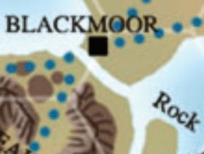
Now you might think when Bledsaw drew a new macro scale map it would reflect his reorintation of the town. Here is Blackmoor on the area map included with the FFC:

Well, that doesn't fit the new town alignment at all. Notice however, how this map places Blackmoor on a micro bay with a small penisula to the west. While this map doesn't square with the reoriented town map, it does fit the look of the earlier town map pretty well, except for the direction of the channel and the road leading south.
In fact, if we assume that east west "river" on the town maps is a local stream coming out of the nearby hills and not the channel that connects Blackmoor Bay with Hope lake, then the only feature not accounted for here is that southern road. There's four roads shown on this map, making it different from the earlier area maps by having a second road to the west, but still no road to the south.
Let's move ahead to the 1980's to see if or how the location of Blackmoor might have been "fixed". (pun intended) First we have the map found in Different Worlds magazine for Arneson's Garbage Pits of Despair adventure.

Now we've only got two roads and again no connecting channel between Hope lake and Blackmoor Bay. It does look as though a third road was intended to the east and never dotted in judging by the gap in the trees though. A comparison of the shape of Rock Island in Hope Lake, the position of the roads and the lack of a river, strongly suggests that the cartographer used the rough sketch map found in the FFC as her model. However, Blackmoor Bay is now shaped much more like what we see in the original town map.
For many though, the "official" Blackmoor is the TSR version published as the DA series. TSR didn't publish a town map but they did publish several area maps, as below:

The TSR map is clearly a close copy of the Bledsaw map. Enough said. Moving on to the 2000's we have two maps from Zeitgeist games. First the hexmap:
Pretty clearly, this copies the TSR map, but interestingly the little peninsula is gone and without it the original town map no longer makes sense because of the shape of the coast. Lets look at the other Zeitgeist map hand drawn by Clayton Bunce:

Okay, we are back to three roads but now one of them goes south out of the town. Most interestingly the channel connecting Lake Hope and Blackmoor Bay is quite wide and Blackmoor town sits on it's shore, not the shore of Blackmoor Bay. In this respect, it looks more like the Bledsaw reoriented town map.
So what to make of all this? When I started looking into these maps I had no expectations of where it would lead, but I think now the solution with the least problems vis a vis canon material is to accept Arneson's original town map and marry it to the coastline of the FFC area map - as I've done crudely but hopefully clearly below. The roads are a little fiddly, but if we presume the west road to Glendower is shown splitting to soon on the town map, then the rest takes care of itself. Let me know what you think.


2 comments:
Nice recap of the migrating locations of Blackmoor! I like the final position, combining the original map of the town with Bledsaw's FFC map.
Thanks Paleo - I should mention that anyone wanting to delve a bit deeper into the town itself should definitely check out your informative post here: https://osrgrimoire.blogspot.com/2019/11/the-town-of-blackmoor.html
Post a Comment